
Embarking on a saltwater fishing expedition requires not only angling skills but also the ability to navigate the vast and often challenging marine environments. A marine navigation GPS chart plotter is an indispensable tool for any serious saltwater angler, providing accurate mapping, tracking, and navigation features to enhance safety and improve fishing success. In this comprehensive guide, we’ll delve into the essential considerations and features that will help you choose the perfect marine navigation GPS chart plotter for your saltwater fishing adventures.
Understanding Marine Navigation GPS Chart Plotters:
A marine navigation GPS chart plotter is a device that integrates GPS (Global Positioning System) technology with nautical charts to provide real-time location tracking, route planning, and navigation assistance. It’s designed to help boaters and anglers navigate safely and efficiently on open waters. For saltwater fishing, a GPS chart plotter becomes an invaluable tool for pinpointing fishing spots, navigating complex waterways, and ensuring a secure return to shore.
Factors to Consider When Choosing a Marine Navigation GPS Chart Plotter:
1. Screen Size and Resolution:
A clear and easily readable screen is essential for quick and accurate navigation. Consider a plotter with a screen size that suits your preferences and provides high resolution for sharp map details, especially when zooming in on fishing hotspots.
2. Chart Compatibility:
Ensure the GPS chart plotter is compatible with the nautical charts for the areas you intend to fish. Many manufacturers offer chart packages specifically tailored to saltwater fishing regions.
3. GPS Accuracy:
Accurate GPS positioning is crucial for safe navigation. Look for a chart plotter with high-quality GPS receivers that provide accurate real-time position information.
4. Mapping and Chart Detail:
Choose a plotter that offers detailed mapping and chart options. High-definition charts with bathymetric data, contour lines, and points of interest are particularly beneficial for saltwater fishing.
5. Waypoints and Routes:
The ability to mark and save waypoints (specific fishing spots, wrecks, reefs, etc.) is essential for anglers. Look for a plotter that allows you to organize waypoints into routes for efficient navigation.
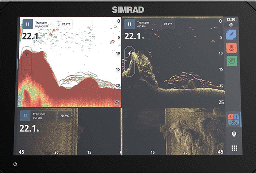
6. Sonar Integration:
Many advanced GPS chart plotters offer sonar integration, allowing you to view underwater structures, depth contours, and fish targets. This feature can greatly enhance your fishing capabilities.
7. Connectivity and Sharing:
Consider whether the plotter can connect to other devices or networks for sharing routes, waypoints, and other information. Wi-Fi and Bluetooth connectivity are common features in modern chart plotters.
8. User Interface:
A user-friendly interface with intuitive controls and menus is essential for efficient navigation. Look for a plotter that offers easy customization and quick access to essential functions.
9. Durability and Weather Resistance:
Since saltwater environments can be harsh, choose a plotter with a rugged design and weather-resistant construction. Ensure it’s built to withstand exposure to saltwater, humidity, and sunlight.
10. Mounting Options:
Consider how you’ll mount the plotter on your boat. Choose a mounting option that provides a clear view of the screen and is suitable for your boat’s layout.
11. Power Supply:
Make sure the plotter’s power requirements are compatible with your boat’s electrical system. Some models offer energy-efficient modes to prolong battery life.
12. Updates and Support:
Regular updates for charts and software are crucial to maintaining accurate and reliable navigation. Opt for a plotter from a manufacturer that provides consistent updates and customer support.
Finding the Right Balance: Inshore vs. Offshore Fishing:
Inshore Fishing:
A GPS chart plotter with a mid-sized screen (7 to 9 inches) for easy visibility.
Prioritize detailed mapping of shallow waters, including flats, channels, and estuaries.
Look for sonar integration to identify underwater structures and track fish movements in inshore waters.
A compact, portable, and mountable plotter is ideal for smaller boats commonly used for inshore fishing.
Offshore Fishing:
Choose a larger screen (9 inches or more) to accommodate the larger distances and complex navigation often involved in offshore fishing.
Prioritize charts that provide depth contours, bathymetric data, and information about offshore structures and seafloor features.
Sonar integration is vital for identifying underwater structures and locating fish targets in deeper offshore waters.
Consider models with GPS capabilities for creating and navigating waypoints, routes, and tracks for longer offshore trips.
A marine navigation GPS chart plotter is a game-changing tool that can elevate your saltwater fishing experience by providing accurate navigation, mapping, and sonar integration. The right choice will depend on your specific fishing needs, whether you’re exploring inshore waters or venturing into the offshore expanse. By considering factors such as screen size, chart compatibility, GPS accuracy, mapping detail, sonar integration, connectivity, durability, and more, you can find a chart plotter that seamlessly guides you through the saltwater environment, helping you reach your fishing destinations with confidence and success.